


sur cou

Louna
User
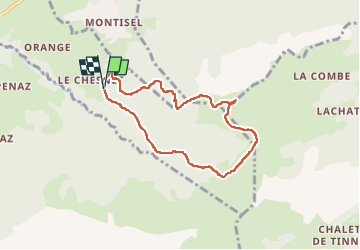

Length
7 km

Max alt
1797 m

Uphill gradient
621 m
Km-Effort
15.3 km

Min alt
1172 m

Downhill gradient
622 m
Boucle
Yes
Creation date :
2025-03-25 08:20:44.434
Updated on :
2025-03-31 15:08:19.891
2h40
Difficulty : Difficult

FREE GPS app for hiking
 SityTrail
IGN / Geographical institutes
SityTrail Plus
The world is yours!
About
Trail Walking of 7 km to be discovered at Auvergne-Rhône-Alpes, Upper Savoy, La Roche-sur-Foron. This trail is proposed by Louna .
Positioning
Country:
France
Region :
Auvergne-Rhône-Alpes
Department/Province :
Upper Savoy
Municipality :
La Roche-sur-Foron
Location:
Unknown
Start:(Dec)
Start:(UTM)
292844 ; 5099904 (32T) N.
Comments